Showing posts with label Hopewell. Show all posts

Sunday, April 7, 2013

Gateway to the Old Northwest


18th century Marietta

The first permanent American settlement in the Northwest Territory officially began at Marietta, Ohio on April 7, 1788.
General Rufus Putnam and 48 men arrived on flatboats and named the new city "Marietta" after Queen Marie Antoinette in honor of France's support during the Revolutionary War.
21st century Marietta
Hostilities with Native Americans, who had occupied the region for thousands of years, would become a fact of life for the next half-century as treaties were made (and broken). By 1843 no Indian tribes would remain in Ohio. Evidence of the Hopewell culture (100 BC - AD 500) can still be seen in what remains of the Marietta Earthworks.

Marietta flourished during the riverboat and railroad era through the 19th century but surpassed in importance as the era of the interstate and air travel took over. Today Marietta has a flourishing tourism industry because of its significant place in history.

Wednesday, January 9, 2013

Olde Coleraine

A replica of Dunlap's Station mentioned in a book.
I had to e-mail some folks to get find its location next to
this coat rack in a closet.
When people in Cincinnati think of Colerain, I'm sure many think of the sea of cars and signs that clog the main drag of the cluttered and overgrown retail area. It's really hard to imagine now but this older suburb of Cincinnati has a rich past of pioneer settlements and prehistoric Indian villages. This older history is largely forgotten or has vanished completely since no physical reminders remain. At least further to the West of Colerain Avenue, there remains open spaces and a few reminders of this community's interesting origins.

Sometimes referred to as Fort Dunlap, Dunlap's Station, or Fort Coleraine this pioneer settlement was founded at the horseshoe bend of the Great Miami River by an Irish immigrant named John Dunlap in 1790. He named the settlement after his birthplace of Coleraine, Ireland.
Today this is the location of Heritage Park where the Boy Scouts have placed a marker commemorating the settlement.

you may have sped right by this informative sign
There were about 40 of these small forts called "Stations" in the late 1700s around the Cincinnati area. This particular Station was significant because it was attacked by the famous Shawnee Chief Blue Jacket and 500 warriors along with the renegade ally Simon Girty, a white man who sided with the local Indians and British against the Americans.
It was nearly impossible for Indians to overtake a Station since they were not equipped with any sort of artillery. The British who sometimes instigated these attacks and provided intelligence rarely lent direct assistance since there was no formal declaration of war at this time with the US. The Native Americans had to resort to intimidation, surprise attacks or just burning stuff down.

Dunlap's Station Marker in Heritage Park
The Siege of Dunlap's Station lasted from January 8th until January 11th, 1791. Two settlers (Sloan and Cunningham) were killed in this attack including one unfortunate man named Abner Hunt. He was held hostage and tortured in full view of the terrified and barricaded residents in an effort to intimidate a surrender from Lieutenant Kingsbury and the Station's defenders.  This tactic proved unsuccessful and the Indian forces finally withdrew after more US military support arrived from nearby Fort Washington in Cincinnati. However, this really wasn't much of a win. These settlers didn't have clear title to the land they purchased from John Dunlap and likely never would. Red tape existed in the 18th century too. All their hard work might be for nothing if they stayed. Added to this was the ever-increasing hostilities with the Indians after St Clairs Defeat later that year. The settlement was soon abandoned.
Settlers returned in 1794 when the area was made more secure after the American win over the Ohio area Indians at the Battle of Fallen Timbers and some of the legal hassles were sorted out.

There is a scaled down replica of the station in the Colerain Township Administrative building. I have since learned that there are plans to build a full-sized replica of Dunlap's Station somewhere in the area as a museum but funding is an issue so the plans are on hold for now. I already let them know that I would love to help build it! I also promised not to attack it.

my kids and I made this grossly inaccurate re-enactment
of the Siege of Dunlap's Station
Hedges Pioneer Cemetery a stone's throw from Dunlap
Next to the park and former location of Dunlap's Station is Hedges Cemetery, a combined graveyard of two old cemeteries where several Revolutionary War veterans are buried along with people who were killed in the 1791 attack, including poor old Abner.

When Heritage Park was being planned in the early 2000's, they ran some ground radar over the area looking for any remnants of Dunlap's Station and they claimed to have found none. The Great Miami River has, in fact, changed course in this area several times, so what little remained is likely to have been washed away over the years.
What they did uncover in the radar survey was more evidence of an ancient 95-acre Indian village that little was known about previously. Rumor has it that the information was hushed to keep the park project on target.  Frisbee golf has a higher priority than history.

Adena Mound atop the hill at River & Dunlap Roads
This 100 BCE Indian village was a prehistoric Hopewell settlement referred to by archaeologists as Colerain Earthworks. There is an 1836 mapped survey of it here. It was located partially on the property of Heritage Park and partially on the private property of Southwestern Ohio Water Works to the north.  An archaeological survey was done recently and the earthen walls appeared as slightly darker lines as compared to the surrounding soil. This confirmed the earlier radar survey and the late 1800s description of  "8 foot walls and 10 foot observation mounds" prior to it being turned into farmland. One of the walls even went right through Hedges Cemetery but just like nearby Northgate Mall no useful features remain.

Adena mound with a house on top
There are also several older 800 BCE Adena Mounds in this area, one is on private property at the top of a hill on private property across from Heritage Park at Dunlap and East Miami River Road.
The other Adena mound is 4 miles away near the Colerain Township Administration building and visible from the road. What is especially odd about this mound is that some time in the 1920's a Tudor style home was built right on top of it. You can still make out the shape of the mound. This home is now used as a garage for the newer home next to it.

Oh, and what happened to the "E" in ColerainE? No one is really sure. Sometimes things just fade away over time and I think they just liked extra E's in words in ye olde days.

sources:
Findagrave.com for Hedges cemetery - specifically, entries for Cunningham, 
Sloan, and Hunt who died at the Siege of Dunlap's Station

Wednesday, January 11, 2012

Local Indian Drowns, Hit By Pontiac

Emily and the Fernbank Indian
In the area known as Sayler Park along the Ohio River west of Cincinnati at the intersection of Gracely & Thornton Avenues is the City of Cincinnati’s smallest park, Thornton Triangle. So they have that going on for them.
In addition to that bit of tiny trivia, in this same park stands the J. Fitzhugh Thornton Memorial. The statue, locally called "Tecumseh" is also known as the Sayler Park Indian, the Fernbank Indian and its catalog name, Indian Chief No. 53. Just like the saga of the American Indian, this effigy has an unusual history which evokes a paradox of civic pride in Sayler Park's modern residents.

Dedicated 100 years ago on January 15, 1912, the memorial was given by Eliza Thornton in memory of her husband John Fitzhugh Thornton who died in 1907. Thornton was an early and prominent resident of the Village of Fernbank, which became part of Sayler Park when the area was incorporated into the city in 1912. I'm not sure why an Indian image was selected by Eliza to memorialize her dead husband. Maybe he just liked Indian history like me. Please make a note of that.

civic pride
The figure was originally cast as Indian Chief No.53 by the J. L. Mott Foundry after a design by Samuel Anderson Robb and was zinc with a cast iron base. It is not on the National Register, however, it is a Cincinnati Historic Landmark.

In the Flood of 1937, the statue was partially submerged and damaged. In 1940 it was hit by a car and then sold as scrap to an antique dealer for $10 before the community raised funds to repair it and bring it back. It was again hit and damaged by a car in 1965 and repaired. Full disclosure, I am not sure if either of these cars were Pontiac's but it made an amusing title for the post. The Fernbank Indian was extensively repaired yet again in 2002 and re-cast in bronze. The "new" statue was re-erected in late 2002 and re-dedicated in 2003. Technically this statue is a bronze reproduction of the cast iron/zinc1912 original.

Indian Chief No. 53
As long as I am on the subject of full disclosure, one thing for certain is that the statue in no way resembles the very non-Woodland Shawnee Chief Tecumseh who lived from 1768-1813 CE and owned a gun. The Late Woodland Indian period ended years prior to Tecumseh and goes back to the pre-Columbian times in 500 BCE. This likeness seems to resemble how Native American Indians may have dressed in this area during the 17th century French LaSalle explorations of Ohio, however, the facial features look very European to me. Ah well, at least they didn't perpetuate the image of a 19th century Plains Indian, you know, the ones you usually see in movies with the big war bonnet fighting cowboys that say "how". Those guys never set foot East of the Mississippi despite what movies, sports logos and bad drawings in history books might lead you to believe. I am in no way disparaging this fine statue. I am just being a stickler for details. It is, in fact, a very dignified representation of an American Woodland Indian from the Ohio Valley.

Short Woods Mound
Also noteworthy and very historically significant are the two nearby and well preserved Adena period mounds.
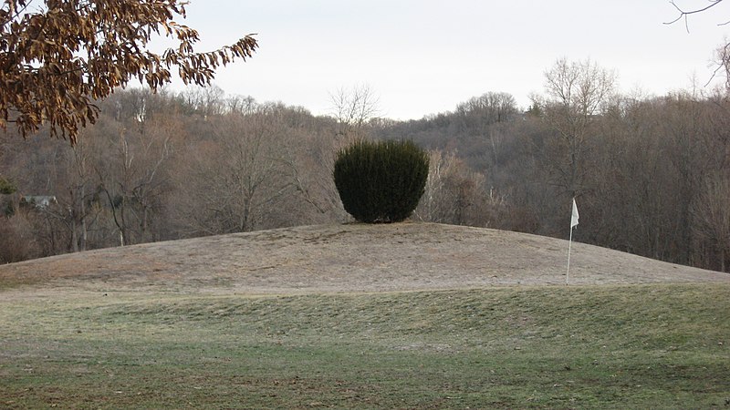
The Short Woods Mound, now on the edge of the local golf course measures 38 feet high by 150 feet wide. It has been excavated and radiocarbon dated to 800 BCE.
Another mound from that era known as the Story Mound is on the property of Sayler Park Elementary. Both mounds were listed on the National Register of Historic Places in the mid 1970's.

I wish I had better pictures of the statue. The sun was not cooperating during my visit in the Summer of 2011 and some of the pictures were lost due to a corrupt memory card. More full disclosure...a geocache brought me here!

Wednesday, July 6, 2011

a visit to Chalahgawtha

one of the many fine murals in town
For Christmas, I received from my wife a gift card to see the award winning 30 year running "Tecumseh!" outdoor stage play in Chillicothe OH. The play is based on the Alan Eckert book The Frontiersman. I must admit that I am not a big Eckert fan for his narrative docudrama writing style and I've only read part of his book "A Sorrow in Our Heart: The Life of Tecumseh" for this reason but I was still pretty excited to witness the epic life story of the legendary Shawnee leader as he struggles to defend his sacred homelands in the Ohio country during the late 1700’s.  It just so happened that opening weekend was on my birthday, so on June 11th, Tricia and I ditched the kids and we drove up and over to Chillicothe located along the Scioto River.
We arrived in the afternoon to grab a few geocaches first (it was my birthday after all) and visit the historical section of town where there are several markers and murals showcasing the city history. I like it when my hobbies merge. You can see the photo album here. I was having some battery issues and I didn't take as many pictures as wanted so I'd have some power for later.

1858 Ross County Courthouse
Columbus OH has been the the state capital since 1816 but Chillicothe was the capital of the entire Northwest Territory as well as the first...and third Ohio state capital. Once from1803-1810 until it was moved to Zanesville for two years and  then moved back to Chillicothe from 1812-1816. It seems some political monkey business had a hand in that shuffle in order to wrestle some party control over eastern Ohio from the Federalists to the Democratic-Republican party.
The name Chillicothe is the anglicized version of the Shawnee word Chalahgawtha, meaning "principal town". There were in fact several Shawnee "Chillicothes" since the Shawnee were semi-nomadic and re-used the name as they moved the town from place to place in the region. When a village was called  Chalahgawtha, it meant that it was home to the principal chief so it was also decided to be used for the name of the new state capital of Ohio when it became the 17th US state in 1803. Many people at that time just loved co-opting Indian words while at the same time they seemed to fear, loathe and look down upon them them and want them all gone. It's a strange love/hate paradox in American history.


St Clair and I meet once again in Chillicothe
While grabbing a geocache in the downtown area, my now highly trained eye spotted a plaque attached to a stone across the street. It turns out that my favorite inept gouty frontier general and Old Northwest Territorial governor Arthur St Clair had his headquarters here from 1800-1802 before President Thomas Jefferson fired him. That was the second time a President dismissed poor ol' St Clair. The first time was when George Washington asked him to resign from the Army after handing the US the worst defeat ever at the hands of the Native Americans in 1791 near present day Fort Recovery, OH. 25% of the entire U.S. Army had been wiped out. The disaster known as St Clair's Defeat was even worse than the later more infamous Custer's Last Stand yet many people have never heard of it. I think the site of him and his gout yelling orders from a litter because he couldn't sit on a horse would make a great scene in a movie. I'll bet Arthur never lived that one down at the Society of Cincinnati meetings over brandies and bonbons.

perhaps Tecumseh himself touched this stone
The impressive looking Ross County Courthouse was also nearby where the original Ohio statehouse stood until it was torn down in 1852. In 1807 Tecumseh himself, escorted in by Ohio Senator and future Governor Thomas "Father of Ohio" Worthington, gave a speech in the original building that was meant to ease tensions between the Native Americans and the nervous Ohio populace. The mission was considered a success and tensions did ease for a while. That would soon change.

There is a road named Nancy Wilson Way and I assumed at the time it was named for the rock musician in Heart. I have since learned that it is named for a different Nancy Wilson, a jazz singer who was from Chillicothe.

There is much more to see here such as the Adena State Memorial and the Hopewell Culture National Historical Park so I will have to come back another time. This day had a greater purpose ahead...

Coming up next...Tecumseh! - The Play